

.png)
.png)
.png)
.png)
.png)
.png)
.png)
.png)
Upper Dolpo Trekking Overview
Upper Dolpo Trekking is one of the most remote and adventurous journeys in Nepal, taking trekkers into a mystical land where time seems to stand still. Hidden deep in western Nepal and bordering Tibet, Upper Dolpo is a land of rugged mountains, barren highlands, sacred lakes, and ancient Buddhist culture. Due to its restricted status and challenging access, the region receives very few visitors, making it one of the purest off-the-beaten-path trekking experiences in the Himalayas.
Landscapes and Wildlife
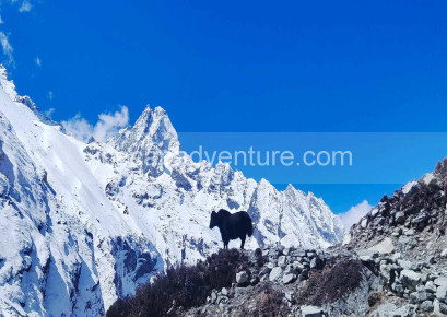
The landscapes of Upper Dolpo are dramatic and varied—arid plateaus, steep gorges, high passes, and windswept valleys. At its heart lies Shey Phoksundo Lake (3,611m), one of Nepal’s deepest and most stunning alpine lakes, known for its turquoise waters. The Shey Phoksundo National Park shelters rare wildlife, including snow leopards, blue sheep, Himalayan wolves, and musk deer, making it a paradise for nature lovers.
Trekking Experience
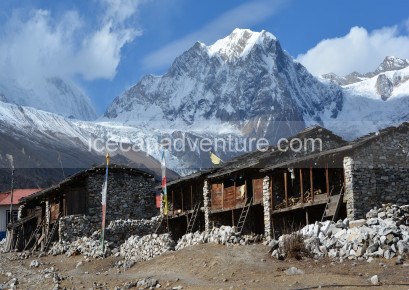
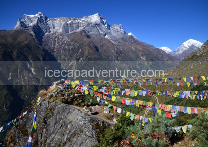
The trek is graded strenuous, often lasting three to four weeks, with long walking days, high-altitude conditions, and multiple passes above 5,000 meters such as Kang La, Jeng La, and Shey La. Trails are remote, with limited facilities, requiring good fitness, proper acclimatization, and a spirit of adventure. Despite the challenges, trekkers are rewarded with pristine wilderness, sacred monasteries, and the rare opportunity to witness untouched Tibetan-influenced culture.
Best Seasons to Visit
The best times to trek Upper Dolpo are spring (April–May) and autumn (September–October) when the skies are clear, and the weather is stable. Unlike Upper Mustang, Dolpo is not suitable during the monsoon due to heavy rains making trails difficult.
Cultural Significance
Upper Dolpo is a living museum of Tibetan Buddhism and Bon traditions. Ancient monasteries such as Shey Gompa stand as spiritual centers, while local festivals bring color and life to the isolated villages. The trek offers deep cultural immersion, where age-old traditions remain untouched by modern influence.
Highlights of the Trek:
-
Exploring the turquoise waters of Shey Phoksundo Lake.
-
Crossing multiple high passes above 5,000m with panoramic views.
-
Spotting rare wildlife, including the snow leopard.
-
Visiting Shey Gompa, an iconic spiritual landmark.
-
Immersing in the traditions of Tibetan-influenced villages.
1
We will be waiting to welcome you at Tribhuvan International Airport, Kathmandu, where you will be greeted with a traditional Nepali flower garland to mark your arrival. After the warm welcome, we will drive you to your hotel—approximately 30 minutes during the day and 20 minutes at night.
Upon reaching the hotel, you will be offered welcome drinks and biscuits, followed by the settlement of your rooms. Once settled, please join us back in the lobby or meeting hall for a briefing about your trekking and tour program, including an introduction to your trekking guide and other relevant details. After the briefing, you will have the opportunity to check your trekking equipment with your guide.
Note: If you arrive in Kathmandu at night, these activities will be scheduled for the following day after breakfast and meals.
2
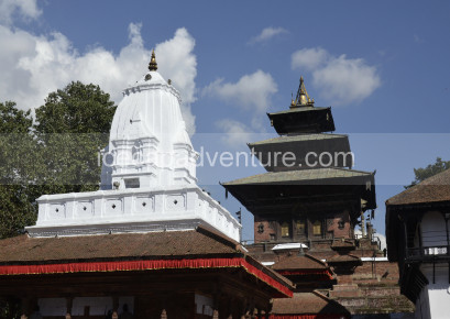
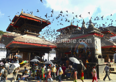
After breakfast at the hotel, you will have time to explore Kathmandu’s cultural heritage sites, such as Kathmandu Durbar Square, Swayambhunath (Monkey Temple), or Boudhanath Stupa, and you will have the day to prepare for your trek.
Our team will assist you in checking your gear and ensuring you have all the necessary equipment for the journey ahead. If you need to buy or rent any trekking gear, we will guide you to the best shops in Thamel, where you can find quality items at reasonable prices.
In the evening, your trekking guide will conduct a final briefing about the trek, including route details, safety measures, and expected weather conditions. Overnight stay at a hotel in Kathmandu.
.
3
After an early breakfast, you'll transfer to Tribhuvan International Airport (Domestic Terminal) for a scenic one-hour flight to Nepalgunj, a bustling city located in the lowlands of western Nepal, near the Indian border. The flight offers stunning aerial views of the Himalayan ranges, with possible glimpses of Langtang, Dhaulagiri, and Annapurna peaks on clear days. Upon arrival in Nepalgunj, you'll check into your hotel and have the afternoon free to relax or explore the area. Despite its low elevation and hot climate, Nepalgunj is a culturally diverse town where Hindu, Muslim, and indigenous communities live side by side. You may choose to visit the Bageshwori Temple, a significant Hindu pilgrimage site, or take a rickshaw ride through the vibrant local bazaars filled with colorful spices, textiles, and street food. This short but important stopover helps you transition from Kathmandu's busy pace to the calm rhythm of the west, while also preparing for your flight into the remote Dolpo region the next day.
Highlights of the Day
-
Scenic flight from Kathmandu to Nepalgunj
-
Explore Nepalgunj's diverse culture and markets
-
Visit Bageshwori Temple (optional)
-
Rest and prepare for remote mountain flight to Dolpo
-
Overnight stay in a comfortable hotel
4
After an early morning breakfast, you will head to Nepalgunj airport for a spectacular flight to Jumla (2,370 m)—the gateway to the remote Karnali region of western Nepal. The 45-minute mountain flight takes you above lush hills, deep river valleys, and scattered villages, eventually landing in one of Nepal’s highest airstrips. Upon arrival in Jumla, you’ll meet your local trekking team, begin organizing your gear, and start your trek towards Gothi Chaur (2,700 m).
The trail from Jumla to Gothi Chaur is a pleasant and relatively short trek, taking about 4 to 5 hours. You’ll walk along the Tila River, passing through charming villages, apple orchards, and mixed forests of pine, oak, and cedar. The gradual ascent introduces you to the less-touched beauty of the Karnali landscape, where the trail is mostly gentle with a few uphill sections. Along the way, you’ll witness traditional lifestyles, terraced farms, and views of snowcapped peaks in the distance.
Highlights of the Day
-
Scenic 45-minute mountain flight from Nepalgunj to Jumla
-
Trek through alpine forests and riverside trails
-
Pass apple orchards and traditional mountain villages
-
Peaceful overnight stay in the alpine meadows of Gothi Chaur
5
After a peaceful night in the alpine meadows of Gothi Chaur, your trek continues deeper into the remote highlands of western Nepal. Today’s trail from Gothi Chaur to Naphukana takes you through dense pine forests, cascading streams, and traditional villages, offering a gradual ascent to an elevation of 3,080 meters. The trek typically takes about 6 to 7 hours, depending on pace and rest breaks.
The route begins with a gentle climb alongside the Tila River, where the sound of flowing water and birdsong creates a serene trekking environment. As you gain elevation, the landscape shifts from lush meadows to mixed forests of pine, fir, and rhododendron. The trail also winds through traditional Khas and Tibetan-influenced villages, giving you a unique window into the rural life of the Karnali region.
You’ll likely stop along the way for a packed lunch or a hot meal prepared by your crew, depending on your trekking arrangement. Continuing your ascent, the trail eventually reaches Naphukana, a small but culturally rich settlement nestled on the hillside. The village is home to a modest Buddhist monastery, and the Tibetan influence in the architecture and local dress is clearly visible. Upon arrival, you'll set up camp near the village or stay in a very basic teahouse, depending on availability and season.
Highlights of the Day
-
Trek through alpine forests and traditional villages
-
Gradual ascent through scenic Karnali landscapes
-
First strong signs of Tibetan Buddhist culture in village life
-
Reach Naphukana, a small hillside village with mountain views
-
Peaceful overnight stay in a remote, highland settlement
6
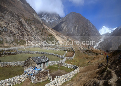
Leaving behind the quiet village of Naphukana, today's trail takes you across rolling hills, highland pastures, and pine-covered ridges on the way to Chaurikot (3,060 m). Though the elevation gain is minimal today, the terrain varies, and the trek typically takes 5 to 6 hours to complete, making it a moderately demanding yet deeply rewarding day. The day begins with a gentle ascent through lush alpine forests, filled with chirping birds and the scent of pine. As you progress along the ridge, you’ll occasionally catch glimpses of distant snowcapped peaks peeking through the trees. The route passes several yak grazing areas and remote herder shelters, highlighting the traditional subsistence lifestyle of the high Himalayas.
After a steady walk through the wilderness, the trail leads to a scenic ridgeline offering panoramic views of the Bheri Valley and surrounding mountain ranges. These open stretches are perfect rest spots, allowing you to soak in the pristine beauty of the Dolpo region.
Continuing along the trail, you’ll gradually descend into Chaurikot, a picturesque village perched on a wide hill slope. The village features traditional stone houses, Buddhist chortens, and prayer flags fluttering in the breeze. It’s one of the more established settlements in the region, often used as a rest point by both trekkers and local herders.
Highlights of the Day
-
Scenic forest trail through alpine ridges and pastures
-
Panoramic views of Bheri Valley and snow-capped peaks
-
Experience local Tibetan-influenced culture and architecture
-
Peaceful overnight stay in Chaurikot village
-
Great acclimatization day before higher altitude trekking
.
7
Today’s trek takes you from the peaceful highland village of Chaurikot (3,060 m) down to the serene banks of the Bheri River (2,610 m). The trail leads through dense pine and oak forests, past remote settlements, and gradually descends into a lower, warmer valley. This transition from highland terrain to river valley brings dramatic changes in vegetation, temperature, and scenery. The trek is mostly downhill and takes around 5 to 6 hours, offering a relatively easy day compared to previous ones.
Departing Chaurikot after breakfast, you'll follow a well-defined trail that winds through rolling ridges and forested slopes. The air grows warmer as you descend, and the landscape shifts from alpine meadows to lush mixed woodlands. Along the way, you may encounter herders moving their flocks and villagers working the land in small hamlets—providing a deeper insight into the rural lifestyle of western Nepal.
As you approach the valley, the mighty Bheri River begins to roar louder. Known for its turquoise waters and powerful flow, the Bheri is a lifeline for much of the region. The riverside offers an ideal camping spot with flat terrain, natural beauty, and the soothing sound of the river in the background. Depending on your setup, you’ll camp on the sandy riverbank or nearby flatlands protected by trees.
Highlights of the Day
-
Beautiful forested descent from alpine to river valley
-
Changing scenery: from pine forests to lush lowlands
-
Walk alongside cascading streams and local villages
-
Camp beside the powerful and pristine Bheri River
-
Opportunity to rest, bathe, and enjoy the tranquil riverside setting
8
Today’s journey from Bheri Riverside to Garpung Khola offers a return to higher altitudes and deeper isolation as you leave the lush river valley and enter the rugged wilderness of the Dolpo region. The trail ascends gradually along the Garpung Khola (river), a glacial-fed tributary that will accompany you for much of the day. Expect to trek around 6 to 7 hours, with a steady elevation gain of nearly 300 meters, as the terrain becomes wilder and more remote.
The day begins with a hearty breakfast at your riverside camp, followed by a moderate climb along a well-trodden but sometimes narrow path. The early section follows the Bheri River before you branch off into the Garpung Valley, a stunning gorge flanked by rocky hills and thick alpine vegetation. This area is rich in biodiversity—you may spot Himalayan monals, blue sheep, or even marmots along the trail.
As you gain altitude, the temperature begins to drop and the vegetation starts to thin. You'll pass through scattered shepherd shelters, small yak pastures, and perhaps even cross basic wooden bridges over glacial streams. This is a true off-the-grid trekking experience, with no villages or teahouses in sight—just the sound of the river, the rustling of the wind, and the vast openness of Dolpo’s wilderness.
Highlights of the Day
-
Scenic riverside trek into the remote Garpung Valley
-
Ascend along the glacier-fed Garpung Khola
-
Spot Himalayan wildlife and alpine flora
-
Isolated camping experience in pristine nature
-
Gradual acclimatization before high-altitude passes
9
Today marks a significant point in your Upper Dolpo via Jumla journey as you ascend from the tranquil riverbanks of Garpung Khola (2,900 m) to the wild, alpine landscapes of Kagmara Base Camp (3,500 m). This is a relatively short but demanding day, with a steady elevation gain of 600 meters and a trekking time of 5 to 6 hours. The trail enters increasingly rugged terrain, surrounded by glacial rivers, sharp ridges, and towering Himalayan peaks.
You’ll begin your day early, climbing steadily along the Garpung Khola, following its winding path through a dramatic, narrowing gorge. The terrain becomes more arid and rocky, with sparse vegetation and a noticeable drop in temperature as you gain altitude. You may cross several icy streams on makeshift wooden bridges or stepping stones, adding a sense of adventure to the day.
As you enter the Kagmara Valley, the landscape opens up to expansive alpine meadows and sharp granite cliffs. With every step, you’re brought closer to the looming Kagmara Himal (5,827 m)—a striking snow-covered peak that dominates the skyline. If the weather is clear, you'll have breathtaking views of surrounding snowfields and glacial formations, offering excellent opportunities for photography and quiet reflection.
Highlights of the Day
-
Scenic and challenging ascent through the Garpung Valley
-
Enter alpine terrain with glacier-fed streams and wild cliffs
-
Breathtaking views of Kagmara Himal (5,827m)
-
Camp at the base of the Kagmara La Pass (5,115m)
-
Experience true Himalayan wilderness in complete isolation
10
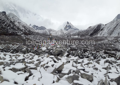
Today’s trek takes you deeper into the heart of the Himalayas as you hike from Kagmara Base Camp (3,500 m) to Kagmara Phedi (4,000 m), a windswept, high-altitude campsite that serves as the final launch point before the Kagmara La Pass. Though the distance isn’t long, the combination of steep terrain, increasing elevation, and thinning air makes this a short but challenging trek, typically taking 3 to 4 hours at a slow, acclimatized pace.
The trail begins with a steady ascent along a barren, glacial valley marked by loose rocks, glacial moraines, and dramatic cliffs. As you gain altitude, the alpine landscape becomes starker and more surreal—a world of jagged ridgelines, scree slopes, and occasional patches of snow, especially in early trekking seasons (April–May or late October).
The route passes yak grazing areas and seasonal herder shelters, though human activity becomes increasingly rare the higher you go. You'll follow a cold, fast-flowing stream fed by the glaciers of Kagmara Himal (5,827 m) as the trail meanders toward the base of the pass.
Reaching Kagmara Phedi (4,000 m), you’ll set up camp in a small, relatively flat area sheltered by the mountain walls. This stark, remote campsite is exposed to wind and colder temperatures, so it’s important to bundle up and rest well. Your crew will prepare warm meals and tea to keep your energy high as you acclimate for the biggest physical challenge of the trek—the Kagmara La Pass crossing the following day.
Highlights of the Day
-
Enter the high-altitude alpine zone above 4,000 m.
-
Stark, dramatic glacial landscapes with scree slopes and moraines
-
Camp at Kagmara Phedi—base of Kagmara La Pass (5,115m)
-
Acclimatization day with minimal exertion
-
Close-up views of Kagmara Himal and surrounding glacier systems
11
Today is the most physically demanding and exhilarating day of the entire Upper Dolpo trek as you conquer the formidable Kagmara La Pass (5,115 m)—one of the highest and most scenic Himalayan passes in western Nepal. Starting from Kagmara Phedi (4,000 m), you’ll ascend steeply to the summit of the pass and then make a long descent through high alpine terrain to the beautiful village of Pungmo, nestled in a remote river valley.
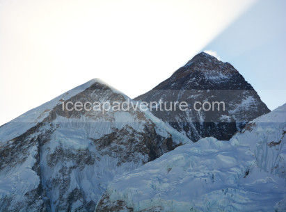
Expect an early start before sunrise to avoid strong afternoon winds at the pass. The trail begins with a steep climb along loose scree, snow patches (depending on season), and glacial moraines. The ascent to Kagmara La is tough and takes 3 to 4 hours, often requiring frequent rest stops due to the thin air and cold temperatures. As you approach the summit, panoramic views open up behind you—the mighty Kagmara Himal (5,827 m), vast Dolpo valleys, and distant Himalayan peaks stretching into Tibet.
Reaching the top of Kagmara La Pass (5,115 m) is a major achievement. Decorated with fluttering prayer flags and framed by raw, wind-swept cliffs, the pass offers one of the most breathtaking viewpoints in all of Dolpo. Take time to catch your breath, soak in the spiritual silence, and snap some unforgettable photos.
Highlights of the Day
-
Cross the majestic Kagmara La Pass (5,115 m)
-
360° views of Himalayan ranges, Dolpo, and Tibetan plateau
-
Challenging high-altitude trekking with snow and scree trails
-
Scenic descent into the remote and forested Pungmo Valley
-
Encounter yak herders, alpine wildlife, and hidden Dolpo culture
12
Today’s trek is one of the most beautiful and culturally immersive days of your Upper Dolpo journey. Leaving the quiet village of Pungmo, you'll follow a spectacular trail that winds through lush pine forests, high cliffs, and roaring waterfalls before arriving at the turquoise-blue Phoksundo Lake—a sacred and awe-inspiring alpine lake at the edge of Shey Phoksundo National Park.
The trail begins with a gentle ascent out of Pungmo, a village with strong Tibetan Buddhist roots. Expect to pass many walls, prayer wheels, and colorful chortens along the way. You’ll gradually climb through birch and fir forests, occasionally glimpsing distant snow peaks and hearing the rush of the Phoksundo Khola (River) below.
As you approach higher ground, the landscape opens up to dramatic cliffs and waterfalls, including a viewpoint that offers a panoramic preview of Phoksundo Lake and the famous Phoksundo Waterfall (approx. 167 m)—Nepal’s highest. This is one of the most iconic photography spots on the trek.
Highlights of the Day
-
Trek through dense alpine forests and high valleys
-
Incredible views of Phoksundo Waterfall, Nepal’s tallest
-
First sight of stunning Phoksundo Lake—sacred & surreal
-
Explore Ringmo village, a Bon cultural center
-
Camp beside one of Nepal’s most beautiful natural landmarks
13
After days of high-altitude trekking and crossing the formidable Kagmara La Pass, today is a well-earned rest and exploration day at the spectacular Phoksundo Lake, one of Nepal’s most sacred and visually arresting natural wonders. This break in the itinerary not only supports acclimatization but also allows you to explore the cultural, spiritual, and ecological richness of the Phoksundo region at a relaxed pace.
Start your day with a warm breakfast by the lakeside, where you can enjoy the surreal view of turquoise waters mirroring snowcapped peaks and barren cliffs. The lake is fed by glacial streams and surrounded by dramatic rock walls, giving it a mystical, untouched quality. It holds deep spiritual significance for followers of Bon and Tibetan Buddhism, and swimming or washing in the lake is respectfully discouraged due to its sacred status.
Highlights of the Day
-
Rest and recovery by the sacred Phoksundo Lake
-
Visit to the 900-year-old Bon monastery
-
Cultural walk through Ringmo village
-
Short hike to the Phoksundo waterfall viewpoint
-
Spiritual tranquility and acclimatization before entering Upper Dolpo proper
14
Today marks the beginning of a new chapter in your Upper Dolpo adventure, as you leave behind the serene turquoise waters of Phoksundo Lake and begin your approach toward the high alpine passes of Baga La (5,190 m) and Numa La (5,318 m). The trek from Phoksundo to Baga La Phedi is a gradual uphill journey that winds through remote valleys, ancient juniper forests, and breathtaking Himalayan scenery.
Starting from Ringmo village, you’ll follow a narrow trail along the lake's eastern shore, gradually ascending through a sparse forest of juniper and birch. The path eventually leaves the lake behind and climbs into a vast, untouched alpine valley, dotted with grazing yaks and seasonal herder shelters.
The air becomes noticeably thinner, and the terrain begins to shift to high-altitude tundra, surrounded by towering rock faces and distant glaciers. You’ll walk alongside glacial streams and may even encounter blue sheep, marmots, and large birds of prey circling overhead. The trail is remote and rugged, and you’re unlikely to meet other trekkers—a true off-the-grid wilderness experience.
Highlights of the Day
-
Trek through pristine alpine wilderness
-
Leave the sacred lake behind and enter remote Dolpo valleys
-
Spot wildlife like blue sheep, marmots & Himalayan eagles
-
Camp beneath the majestic cliffs of Baga La
-
Prepare for one of Dolpo’s most beautiful high pass crossings
15
Today is one of the most rewarding and dramatic high-altitude days on your Upper Dolpo Trek, as you cross the Baga La Pass (5,090 m)—a wild and windswept col offering 360° Himalayan panoramas—before descending into the wide valley below to reach Numa La Phedi, the base of your next major pass.
Begin early from your camp at Baga La Phedi (4,200 m) to avoid harsh afternoon winds and potential weather changes. The ascent to Baga La Pass is a challenging 3- to 4-hour climb along steep, zigzagging trails through scree slopes and loose rock. The climb is strenuous due to the thin air and altitude, so a slow, steady pace is essential.
Reaching the summit of Baga La (5,090 m) is a moment of true accomplishment. The pass is adorned with colorful prayer flags, fluttering in strong winds against a backdrop of snow-capped peaks, glacial valleys, and vast Dolpo wilderness. On clear days, you can spot distant Tibetan peaks to the north and the Kanjiroba Himal to the south. This is a perfect place for quiet reflection, photography, and a quick tea break (if conditions allow).
Highlights of the Day
-
Cross the remote and spectacular Baga La Pass (5,090 m).
-
Panoramic views of Dolpo’s untouched Himalayan terrain
-
Deep solitude and silence of Dolpo's high passes
-
Descend into a hidden valley surrounded by cliffs and glaciers
-
Camp at Numa La Phedi—base of Dolpo’s highest trekking pass
16
Today marks the highlight and highest point of the Upper Dolpo trek as you ascend to and cross the formidable Numa La Pass at 5,360 meters (17,585 feet)—the highest pass on this iconic route. Starting early from the camp at Numa La Phedi (approx. 4,800 m), you face a steep and physically demanding climb over loose scree, snow patches (depending on season), and rugged terrain.
The climb to Numa La is challenging due to the extreme altitude and variable weather, often requiring trekking poles and careful pacing. As you reach the summit, you are rewarded with spectacular 360° views of the Kanjiroba Himal, Shey Phoksundo National Park, and the remote Tibetan plateau. The pass is marked by colorful prayer flags fluttering against the vast sky, creating a deeply spiritual atmosphere.
After soaking in the breathtaking scenery, the descent begins, dropping steeply down rocky and grassy slopes into a high alpine valley. The trail passes yak grazing grounds, small herder camps, and alpine meadows rich in wildflowers during summer months.
Highlights of the Day
-
Ascend and cross the highest point of the trek, Numa La Pass (5,360 m).
-
Panoramic views of the Kanjiroba range and vast Dolpo wilderness
-
Experience the rugged alpine landscape of Upper Dolpo
-
Descend into the picturesque and peaceful village of Do (4,100 m).
-
Encounter traditional Dolpo culture and hospitality
17
After the physically demanding crossing of the Numa La Pass (5,360 m), today is a well-deserved rest and acclimatization day in the traditional mountain village of Do, nestled at 4,100 meters. This pause in the trek allows your body to recover from high-altitude exertion, reducing the risk of altitude sickness while offering a chance to soak in the unique Dolpo culture and stunning alpine environment.
Spend your morning relaxing in your guesthouse or camp, sipping traditional herbal tea, and enjoying the crisp mountain air. The village is surrounded by vast meadows dotted with grazing yaks and stone houses adorned with colorful prayer flags, reflecting the strong Tibetan Buddhist influence.
Highlights of the Day
-
Rest and acclimatize at 4,100 meters
-
Explore traditional Dolpo village life and culture
-
Visit local monastery and prayer wheels
-
Gentle nature walks and wildlife spotting
-
Prepare physically and mentally for the next trekking segment
18
After a restful day in the tranquil village of Do, today’s trek takes you gently downhill through spectacular alpine valleys as you make your way towards Lahini, situated at a lower elevation of 3,560 meters. This descent provides welcome relief after the high passes and offers a chance to soak in more of Dolpo’s unique landscapes and cultural heritage.
Leaving Do, the trail winds through open meadows and scattered stone settlements, following alongside sparkling streams fed by melting glaciers. The trek offers excellent opportunities to spot wildlife such as Himalayan blue sheep and colorful alpine birds, while prayer flags flutter above stone chortens (stupas), highlighting the region’s deep Buddhist roots.
The path is mostly gradual with occasional steeper sections, passing through fields of wildflowers during summer and clusters of juniper and rhododendron trees. Along the way, you may encounter local shepherds with their yaks and goats, giving you a glimpse into the traditional pastoral lifestyle of Upper Dolpo.
Highlights of the Day
-
Scenic descent from high alpine village Do to Lahini
-
Trek through wildflower meadows, alpine forests, and yak pastures
-
Spot local wildlife and observe traditional herding life
-
Pass ancient Buddhist shrines and prayer flags
-
Rest and refresh in the peaceful village of Lahini
19
Today’s trek continues descending through the enchanting valleys of Upper Dolpo as you journey from Lahini to the lower elevation village of Tarakot (2,600 m). This stage offers a refreshing change in scenery as you leave the high alpine landscape behind and enter lush, forested hillsides and cultivated farmlands.
The trail gradually descends through terraced fields, mixed forests of pine and rhododendron, and quaint villages where local farmers tend their crops. Along the way, you’ll pass traditional stone houses and small gompas (monasteries), reflecting the rich cultural heritage of the Dolpo region.
The fresh mountain air, combined with views of rugged cliffs and distant peaks, makes this stretch particularly scenic. The trek is moderately challenging due to the length of descent but offers plenty of chances to rest and take photos.
Highlights of the Day
-
Scenic descent through terraced fields and mixed forests
-
Experience traditional Dolpo village life and mountain farming
-
Pass local gompas and stone houses reflecting Tibetan Buddhist culture
-
Reach Tarakot, a lively mountain town with teahouses and markets
-
Prepare for onward journey with warm meals and rest
20
Today’s trek descends further into the serene valley as you journey from the lively mountain town of Tarakot down to Dunai, the administrative center of the Dolpo region situated at 2,100 meters. This leg offers a noticeable change in landscape, moving into greener foothills with denser forests and cultivated farmland.
The trail meanders through beautiful pine and oak forests, with occasional glimpses of terraced fields and traditional stone houses scattered along the route. Along the way, you may encounter local villagers going about their daily routines, giving insight into the rural lifestyle of Dolpo.
Dunai is a small town with more facilities than previous villages, including guesthouses, shops, and a health post. It serves as a key stopover for trekkers finishing the Upper Dolpo circuit or heading towards Nepalgunj. Upon arrival, you can relax, enjoy warm meals, and explore the local market area.
Highlights of the Day
-
Scenic descent through mixed forests and agricultural lands
-
Experience rural Dolpo village life and traditional stone houses
-
Reach Dunai, the main administrative town of the region
-
Opportunity to restock supplies and enjoy local hospitality
-
Prepare for onward travel by road or air from Dunai
.
21
Starting your journey from Dunai, the administrative hub of Dolpo, today’s trek leads you uphill to Juphal, situated at an altitude of 2,500 meters. Juphal is a crucial gateway town, serving as the launching point for flights to Nepalgunj and the start of your high-altitude Dolpo adventure.
The trail climbs steadily through mixed forests of pine, fir, and rhododendron, offering refreshing mountain air and occasional views of surrounding Himalayan peaks. You’ll pass through small villages and farmland, where locals cultivate barley and buckwheat, embodying the resilient lifestyle of the Dolpo people.
Reaching Juphal, you’ll find a small airstrip with a handful of teahouses and lodges. This is the last point where you can enjoy some relative comfort before heading deeper into the remote Upper Dolpo region. It’s a perfect place to rest, organize gear, and mentally prepare for the challenging trekking ahead.
Highlights of the Day
-
Steady uphill trek through mixed Himalayan forests
-
Experience rural village life with terraced fields and traditional farming
-
Reach Juphal, gateway to Upper Dolpo and the domestic airstrip
-
Final opportunity to prepare and stock up before high-altitude trekking
-
Scenic mountain views along the route
.
22
After completing the incredible Upper Dolpo trekking adventure, today you’ll take a scenic domestic flight from Juphal Airport back to Nepalgunj (approximately 150m altitude), followed by a connecting flight to Nepal’s capital, Kathmandu (1,400 m altitude).
Flight from Juphal to Nepalgunj:
The flight from Juphal is a spectacular experience, offering breathtaking aerial views of the rugged Himalayan terrain, deep river valleys, and remote villages you trekked through. The small aircraft usually takes about 30 to 40 minutes, depending on weather conditions.
Nepalgunj is a bustling city and an important gateway to western Nepal. Upon arrival, you’ll have time to relax and possibly explore local markets or enjoy a meal before catching your next flight.
Connecting Flight from Nepalgunj to Kathmandu:
The onward flight from Nepalgunj to Kathmandu lasts around 45 minutes to 1 hour. This flight offers beautiful views of the sprawling Terai plains, the foothills of the Himalayas, and the Kathmandu Valley itself as you approach the city.
Upon arrival in Kathmandu, you’ll be transferred to your hotel or continue with your onward travel plans. Kathmandu offers a vibrant mix of cultural heritage, historic temples, and lively markets—the perfect place to conclude your Dolpo adventure.
Highlights of the Day
-
Spectacular aerial views of the Dolpo region during Juphal to Nepalgunj flight
-
Experience domestic flights in remote Nepal
-
Arrival in Nepalgunj, a gateway city in western Nepal
-
Short connecting flight to Kathmandu with panoramic mountain views
-
Return to Nepal’s cultural capital after your trekking expedition
23
After your incredible Upper Dolpo trekking adventure and return flights, today is dedicated to resting, recovering, and exploring the vibrant capital city of Kathmandu. This day gives you a well-deserved break to relax your body, reflect on your journey, and soak up the rich culture and bustling atmosphere of Nepal’s historic city.
Highlights of the Day
-
Rest and recover after a demanding trek
-
Explore Kathmandu’s bustling Thamel district for shopping
-
Purchase authentic Nepali souvenirs and handicrafts
-
Experience local culture through cuisine and markets
-
Optional visits to iconic temples and heritage sites
24
After an unforgettable adventure through the Himalayas, today marks the conclusion of your Nepal journey. Depending on your flight schedule, our team will arrange a comfortable transfer to Tribhuvan International Airport (TIA) in Kathmandu, located approximately 6 km from the city center. We recommend arriving at the airport at least 3 hours prior to international departures to allow time for security and check-in procedures. As you take off, you’ll carry with you not only beautiful photographs but also lasting memories of Nepal’s vibrant culture, spiritual depth, and majestic landscapes. Safe travels, and we hope to welcome you back again soon!

Didn’t find what you were looking for?
So why not plan your own trip. It takes only 2 minutes.- Airport Pick up and transfers to hotel.
- All accommodation in Kathmandu and Trekking.
- Full boards meals during Trekking such as: breakfast, lunch and dinner.
- Properly 3 times tea and coffee whatever hot drink are available.
- Full support crew with 1 porter for every 2 trekkers.
- Experience professional guide and porter.
- Full insurance for guide and porter.
- All transportation from the starting to ending points of the trip.
- All domestic flight tickets kathmandu to Nepalgunj to Jumla and Jupla to Nepalgunj to Kathmandu.
- National park entry fee and TIMS card or trekking permit whatever needed.
- All taxes as necessaries by Nepal government.
- Trekking maps and Notebook.
- Down Sleeping bag (-20), Trekking stick / pole and Potter bag ( Luggage).
- First Aid Kit for staff.
- Trekking achievement certificate after completed the Treks.
- All international flight tickets, travel insurance and Nepal entry visa fees.
- Lunch and dinner in Kathmandu.
- All hard drinks such as : Mineral water, whisky, rum, cola, fanta, etc.
- Extra entrance fees such as Museum, Monastry, Temple, Boating, etc.
- Personal expenses like hot shower and battery charge /wifi.
- Personal equipment.
- Any emergency rescue evacuation and extra cost offering from unfavorable circumstance such as weather bad.
- Personal tips for trekking staff.
Good to Know – Upper Dolpa Trekking
-
Best Seasons to Trek: The ideal trekking seasons are spring (March–May) and autumn (September–November), offering clear skies and moderate temperatures. Winter brings heavy snow and extreme cold, while the monsoon (June–August) can make trails slippery.
-
Altitude Awareness: Treks reach altitudes of 4,500–5,200 meters, so altitude sickness is a real risk. Take acclimatization days, ascend gradually, and stay well-hydrated.
-
Physical Fitness: Upper Dolpa is a challenging trek requiring high endurance. Daily trekking can range from 6–9 hours over rugged terrain with steep ascents and descents. Pre-trek training is strongly recommended.
-
Permits Required: Trekkers need a Restricted Area Permit (RAP) for Dolpa, which requires travelling with a registered guide. Additionally, a TIMS card is mandatory.
-
Accommodations and Meals: Lodging is basic in this remote region. Tea houses provide simple rooms and meals, including dal bhat, noodles, soups, and limited Western options.
-
Drinking Water: Bottled water is limited and expensive. Carry a water filter or purification tablets for safe drinking.
-
Packing & Gear: Essentials include warm and layered clothing, trekking boots, a sleeping bag, a waterproof jacket, walking poles, sunscreen, a hat, and a personal first-aid kit. Prepare for extreme cold and dry conditions.
-
Flight & Transportation: Most treks start with a flight from Nepalgunj to Juphal, followed by trekking. Road options exist, but are long and challenging.
-
Connectivity: Mobile networks and the internet are limited; many remote villages have no coverage. Some lodges may offer paid Wi-Fi with slow connections.
-
Travel Insurance: Comprehensive insurance covering high-altitude trekking, restricted area travel, medical emergencies, and helicopter evacuation is essential.